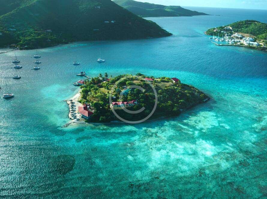
PRECISION AERIAL IMAGING, REAL-WORLD SOLUTIONS
Frank Dominick Schilleci
Owner/Chief Pilot-in-CommandAGL Drone Imagery LLC provides professional aerial imagery and data services built on aviation discipline, operational experience, and a commitment to safety, integrity, and reliability. While AGL delivers high-quality visual documentation and geospatial products, the foundation of every mission is sound risk management, clear communication, and responsible flight operations.
AGL primarily serves northeastern North Carolina, with availability for deployments beyond the region when requested.

Proven Aviation and Public Safety Professional
AGL is led by Dominick Schilleci, whose background spans military aviation, federal oversight, and public safety operations. His experience includes aviation mission planning, federal search and rescue coordination, FAA airworthiness inspection, and certified unmanned aircraft operations in regulated and sensitive environments.
Dominick has supported joint task force activities involving federal, state, and local agencies, including airport risk mitigation, unmanned aircraft regulatory enforcement support, and operational planning related to complex airspace and infrastructure protection. This background informs how AGL approaches every project, emphasizing disciplined operations, situational awareness, and accountability.
Operational Experience Applied in the Field
Dominick Schilleci
Beyond documentation, AGL supports real-world operations when activated by authorized organizations. This includes assisting fire departments, emergency management teams, and other agencies during training exercises, incident response, and search and rescue activities. Aerial platforms are used to enhance situational awareness, support incident command decisions, and reduce risk to personnel on the ground.
AGL also provides aerial support for non-profit organizations, community events, and preparedness activities, contributing to broader community risk reduction efforts. Whether the mission involves property documentation, infrastructure monitoring, emergency response support, or environmental observation, AGL adapts its approach to the client’s needs while maintaining a consistent safety-first standard.
We Work with the Best Drones
We combine advanced drone technology with professional expertise to deliver high-precision visuals that stand out. Our team uses industry-leading equipment to capture detailed aerial footage and photography with clarity, stability, and cinematic quality.
Adipiscing elit sed do eiusmod tempor incididunt ut labore et dolore magna aliqua. Ut enim ad minim veniam, natus error sit voluptatem accusantium doloremque laudantium.
Veritatis et quasi architecto beatae vitae dicta sunt explicabo. Nemo enim ipsam voluptatem quia voluptas, sed quia consequuntur magni dolores eos.
Professional Credentials and Operating Principles
Current Affiliations
South Mills Volunteer Fire Department, Remote Pilot Operations
U.S. Coast Guard Auxiliary, Designated Search and Rescue Unmanned Aircraft Systems Remote Pilot
Cajun Navy, Volunteer Support Member
Prior National and Federal Experience
Joint Authorities for Rulemaking on Unmanned Systems (2018–2021)
General Aviation Safety Assurance – Unmanned Aircraft Systems Outreach and Rulemaking (2018–2021)
Unified National Response Planning for Persistent Unmanned Aircraft Disruptions at Major Airports (2018–2021)
Department of Justice Joint Terrorism Task Force Support Activities (2018–2021)
FAA STEM Outreach Program, Outreach Representative (2018–2020)
This experience reinforces AGL’s ability to operate responsibly in complex environments while delivering clear, accurate aerial data that clients can trust.
Operating Principles
AGL’s work is guided by three core values:
Safety – Every mission begins and ends with risk awareness and responsible aviation practices
Integrity – Transparent communication and ethical operations
Reliability – Consistent results clients can depend on, before, during, and after deployment
These principles allow AGL to remain flexible and adaptable, working with clients to understand their challenges and tailor aerial solutions that save time, reduce costs, and lower operational risk.
The latest news


AGL Drone Imagery provided excellent aerial photos for our property listing. The images were clear, well-framed, and effectively highlighted the property layout. The whole process was professional, safe, and organized from beginning to end.
Professional, Safe, and Extremely Detailed
AGL Drone Imagery provided exactly what we needed after a storm—clear roof images organized and ready for insurance review. The service was efficient, professional, and safety-focused.
Safe, Efficient, and Insurance-Ready Imagery
We needed roof condition imagery without putting anyone on ladders. AGL Drone Imagery provided clear, high-resolution photos that were perfect for documentation and maintenance planning. Fast turnaround and very professional service.
Excellent Roof Documentation Service
FACTS & FREQUENTLY ASKED QUESTIONS (FAQ)
1) What exactly does AGL Drone Imagery LLC do?
AGL Drone Imagery provides professional aerial photography, video, mapping, and 3D documentation designed to turn aerial imagery into clear, decision-ready information. Depending on your project, we deliver edited photos, edited videos, scaled site visuals, 3D models, elevation visuals, and documentation packages that help you plan, verify conditions, and communicate clearly.
2) How is this different from hiring someone who just takes drone photos or videos?
Most operators deliver good-looking footage. AGL focuses on repeatable, precise capture and professional processing workflows that improve consistency and usefulness, especially for construction, agriculture, and post-storm documentation.
3) What areas do you serve?
AGL Drone Imagery proudly serves Camden, Elizabeth City, Pasquotank, Currituck, South Mills, Gates County, Moyock, the Outer Banks, and surrounding northeastern North Carolina. Travel beyond the included service area is available as outlined in the Pricing Guide.
4) How does pricing work, and why is it shown as a range?
Pricing is shown as a range because every site is different. Final pricing is based on property size, obstacles, flight complexity, time on site, and FAA airspace authorization requirements.
5) What video format will I receive—horizontal or vertical?
You choose the format based on how you plan to use it. Horizontal video is best for websites, YouTube, and standard Facebook posts. Vertical video is best for Instagram Reels, TikTok, and Facebook Reels.
6) What deliverables will I receive?
Deliverables depend on the selected package and project goals and may include edited photos, edited video clips, cinematic videos, or advanced mapping deliverables. Raw photo and video files are available as optional add-ons.
7) How soon will I receive my deliverables?
Typical delivery timelines begin after the flight is completed. Photos and video clips are usually delivered within 5–7 business days. Cinematic videos typically take about 7 business days. Premium packages may take 7–10 business days.
8) What about FAA airspace authorization and scheduling?
Some locations require FAA airspace authorization before flight. Approvals can take up to three weeks, though many are completed within 5–10 business days. Flights are also weather-dependent.
9) Are your services legal and compliant in North Carolina?
Yes. All operations are conducted under FAA rules. AGL Drone Imagery provides aerial imagery and visual documentation services only.
10) Do your services replace licensed surveyors or engineers?
No. AGL Drone Imagery does not provide boundary determinations, legal property descriptions, certified measurements, engineering, or architectural services. Licensed professionals should be consulted where required.
11) How do I get started?
Call or text (252) 621-3006 or email info@AGLDroneImagery.com. We will discuss your goals, confirm scheduling and airspace requirements, and recommend the best deliverables for your project.
Legal & Operational Disclaimer
All aerial imagery, data, visualizations, and documentation provided by AGL Drone Imagery LLC are intended for visual reference, documentation, situational awareness, and decision-support purposes only. Deliverables are not intended for legal boundary determination, land surveying, engineering analysis, structural certification, or regulatory compliance determinations unless explicitly stated in writing and authorized by applicable regulations.
AGL Drone Imagery LLC operates as a non-enforcement, documentation-focused support provider and does not exercise law enforcement authority. Public safety, search and rescue, and incident-support operations are conducted only when authorized, requested, or integrated with responsible agencies or organizations.
All operations are conducted in accordance with applicable Federal Aviation Administration regulations, airspace requirements, and safety standards. Emergency situations require immediate contact with local emergency services by calling 911 prior to any aerial support considerations.
Start the Conversation
Call or Text: 252-621-3006
Email: info@agldroneimagery.com