OPERATIONAL AERIAL IMAGING & THERMAL SOLUTIONS

Frank Dominick Schilleci
Founder & Lead Aerial Data Collection Specialist
AGL Drone Imagery LLC provides professional aerial imaging, thermal documentation, and operational support services designed to help organizations improve visibility, reduce risk, and support faster decision-making. Built on aviation discipline and real-world operational experience, AGL delivers visual documentation solutions tailored to infrastructure, property, industrial, agricultural, and public safety environments.
Every mission is approached with a safety-first mindset focused on clear communication, responsible flight operations, and dependable visual documentation that supports real-world operational needs.
AGL primarily serves northeastern North Carolina, with availability for select deployments beyond the region when requested.
AGL also supports operational and emergency-response environments when requested or coordinated through authorized organizations. This includes assisting training exercises, search operations, incident support activities, and situational awareness missions designed to improve operational visibility while reducing on-site risk to personnel.
In addition to commercial and infrastructure-focused projects, AGL supports community organizations, preparedness initiatives, and environmental observation efforts through adaptable aerial imaging and thermal documentation workflows tailored to the needs of each operation.
ABOUT AGL
Aviation, Public Safety, and Operational Leadership
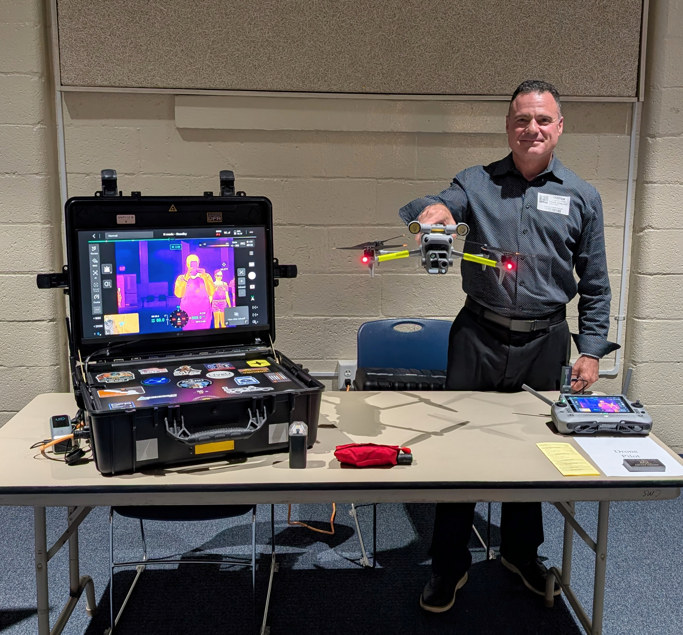
AGL is led by Dominick Schilleci, whose background spans military aviation, FAA oversight, public safety support operations, and unmanned aircraft systems instruction. His experience includes aviation mission planning, FAA airworthiness inspection, FAA Part 107 flight operations, and operational coordination in regulated and safety-sensitive environments.
Dominick currently supports unmanned aircraft operations with the South Mills Volunteer Fire Department and the U.S. Coast Guard Auxiliary, while also assisting with interagency training involving public safety and emergency response organizations. This includes instruction related to operational safety, situational awareness, incident coordination, and responsible flight operations.
His prior federal experience includes aviation safety oversight, unmanned aircraft systems outreach and rulemaking support, airport risk mitigation planning, and coordination efforts involving complex airspace and infrastructure-sensitive environments.
This operational background influences how AGL approaches every project, emphasizing disciplined planning, risk awareness, clear communication, and dependable aerial data collection focused on real-world client needs.
Operational Experience Applied in the Field
AGL Drone Imagery applies aviation discipline, operational planning, and field experience to real-world aerial data collection missions. Projects are approached with a strong emphasis on safety, situational awareness, communication, and mission efficiency.
Experience supporting training operations, infrastructure documentation, emergency management coordination, and complex operating environments helps AGL adapt to changing conditions while maintaining professional operational standards.
Professional Credentials
and Operating Principles
Current Affiliations
South Mills Volunteer Fire Department, Remote Pilot Operations
U.S. Coast Guard Auxiliary, Designated Search and Rescue Unmanned Aircraft Systems Remote Pilot
Cajun Navy, Volunteer Rescue Support Member
Level I sUAS Certified Infrared Thermographer
Prior Federal and National-Level Experience
Joint Authorities for Rulemaking on Unmanned Systems (2018–2021)
General Aviation Safety Assurance – Unmanned Aircraft Systems Outreach and Rulemaking (2018–2021)
Unified National Response Planning for Persistent Unmanned Aircraft Disruptions at Major Airports (2018–2021)
Department of Justice Joint Terrorism Task Force Support Activities (2018–2021)
FAA STEM Outreach Program, Outreach Representative (2018–2020)
This experience reinforces AGL’s ability to operate responsibly in complex environments while delivering professional aerial data collection and operational support services clients can trust.
Operating Principles
AGL’s work is guided by three core values:
Safety – Every mission begins and ends with risk awareness and responsible aviation practices
Integrity – Transparent communication and ethical operations
Reliability – Consistent results clients can depend on, before, during, and after deployment
These principles allow AGL to remain adaptable across a wide range of aerial documentation and operational support missions while maintaining a consistent safety-first approach.
Legal & Operational Disclaimer
All aerial imagery, visualizations, thermal imagery, overlays, terrain models, volumetric calculations, and related documentation provided by AGL Drone Imagery LLC are intended for visual reference, situational awareness, documentation, inspection support, and decision-support purposes only.
Deliverables are approximate visual representations and are not intended for legal boundary determination, land surveying, engineering analysis, structural certification, permitting, or regulatory compliance determinations unless explicitly authorized in writing and performed in accordance with applicable laws and licensing requirements.
Approximate GIS-based overlays, property outlines, contours, elevation models, and volumetric outputs are provided for visualization and planning purposes only and should not be relied upon as authoritative measurements or survey-grade products.
AGL Drone Imagery LLC operates as a documentation-focused aerial data and imaging provider and does not exercise law enforcement authority or emergency response command functions. Public safety, search and rescue, and incident-support activities are conducted only when authorized, requested, or coordinated with the responsible agencies or organizations.
All operations are conducted in accordance with applicable Federal Aviation Administration regulations, airspace requirements, operational limitations, and safety standards. In emergency situations, contact local emergency services by calling 911 prior to requesting aerial support assistance.
Start the Conversation
Reducing Risk. Saving Time.
Delivering Clarity
Elizabeth City, North Carolina
Contact Us
License & Certifications
 Veteran-Owned Business
 FAA Part 107 Certified UAS Pilot
 FAA Airframe & Powerplant (A&P) Licensed
 FCC Licensed
 AGL Drone Imagery LLC does not provide licensed land surveying or certified measurement services.
- 🌡️ Level I UAS Thermography Certification – Infrared Training Center (FLIR)
- ⚓ U.S. Coast Guard Auxiliary – Remote Pilot in Command (Operational Support)
- DJI Enterprise Platform Experience (Matrice Series)
© Copyright 2026. All rights reserved. Website by Vareweb.